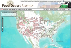
For many Arizona residents, there is little question that they live in the desert as far as the climate goes. However, many of those same residents also live in a food desert according to the new internet food desert mapping tool recently released by the USDA. This tool, that shows which portions of the country have limited access to affordable, nutritious food, was created to help policy makers and community leaders understand which communities would most benefit from aid and intervention.
First used in the U.K in the 1990’s, a food desert is a community where poverty is present, transportation is limited and access to supermarkets is lacking. The USDA’s new tool takes the U.S. census data and applies it to the following criteria to designate which census tracts are food deserts.
- At least 20% of the residents of that tract are at or below the poverty level or the median family income in that tract is at or below 80% of the median family income in surrounding communities.
- For urban areas, at least 500 people or 33% of the population of that tract live more than 1 mile from a supermarket.
- For rural areas, at least 500 people or 33% of the population of that tract live more than 10 miles from a supermarket.
Using these criteria, about 6,500 census tracts in the U.S. or 10% of the tracts, are considered food deserts. This equates to more than 13 million people. Although a brief review of the U.S. map seems to indicate that the problem is greatest in rural areas, because of population concentrations, about 82% of those who live in food deserts are actually residents of urban areas.
The Food Desert Locator pairs mapping technology with census data enabling community leaders and other interested parties to view statistics at the lowest levels of detail. This is a key strength of the Food Desert Locator as it allows for the planning and implementation of very targeted initiatives that are specific to the community in need, an approach that has proven most effective in the past.
Building on the release of the Food Environment Atlas last year, the Locator provides the next level of detailed data specific to food accessibility. Both initiatives were completed in conjunction with the First Lady’s Let’s Move initiative which seeks to address the problem of childhood obesity plaguing the country. By understanding where there may be food accessibility issues, government agencies and local aid groups can maximize their effectiveness.
Here in Arizona, there are several areas of the state designated at food deserts. Large chunks of the northeast and southwest corners of the state and areas of all the major cities qualify under the USDA criteria. To see if your community is considered a food desert, you can view the maps and information here.
If you live in a food desert, what can you do as the price of transportation and food continue to rise? Seek out local the farmers market and farms and grocery stores that purchase locally for your fresh fruits, vegetables, eggs, dairy and meats. By locating local options for perishable items you can limit your trips to the supermarket and improve your diet without increasing your overall cost. To find a list of local markets, farmers and even grocers, go to https://fillyourplate.org. You might also consider starting or joining an existing community garden to have access to fresh fruits and vegetables in your community. You can find more information about gardening in Arizona from the University of Arizona Extension Office.


Pingback: Watch Out Cheddar, You’ve Got Some Competition! | Fill Your Plate Blog